
Thank you for supporting this site ❤️
Make a donation
Make a donation
Mars topographic map
Click on the map to display elevation.
Thank you for supporting this site ❤️
Make a donation
Make a donation
About this map
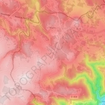
Name: Mars topographic map, elevation, terrain.
Average elevation: 1,029 m
Minimum elevation: 684 m
Maximum elevation: 1,141 m
Thank you for supporting this site ❤️
Make a donation
Make a donation
Other topographic maps
Click on a map to view its topography, its elevation and its terrain.
Thank you for supporting this site ❤️
Make a donation
Make a donation
Hameau de Romanieux
France > Auvergne-Rhône-Alpes > Ardèche > Saint-Alban-d'Ay
Average elevation: 710 m
Thank you for supporting this site ❤️
Make a donation
Make a donation
Thank you for supporting this site ❤️
Make a donation
Make a donation
Thank you for supporting this site ❤️
Make a donation
Make a donation
Saint-Pierre-la-Roche
France > Auvergne-Rhône-Alpes > Ardèche > Saint-Pierre-la-Roche > Saint-Pierre-la-Roche
Average elevation: 461 m
Thank you for supporting this site ❤️
Make a donation
Make a donation