
Thank you for supporting this site ❤️
Make a donation
Make a donation
Lendorf topographic map
Click on the map to display elevation.
Thank you for supporting this site ❤️
Make a donation
Make a donation
About this map
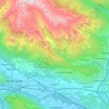
Name: Lendorf topographic map, elevation, terrain.
Location: Lendorf, Bezirk Spittal an der Drau, Carinthia, 9811, Austria (46.81048 13.37796 46.91256 13.47917)
Average elevation: 1,235 m
Minimum elevation: 537 m
Maximum elevation: 2,742 m
Thank you for supporting this site ❤️
Make a donation
Make a donation
Other topographic maps
Click on a map to view its topography, its elevation and its terrain.