
Thank you for supporting this site ❤️
Make a donation
Make a donation
Eschenberg topographic map
Click on the map to display elevation.
Thank you for supporting this site ❤️
Make a donation
Make a donation
About this map
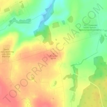
Name: Eschenberg topographic map, elevation, terrain.
Average elevation: 39 m
Minimum elevation: 6 m
Maximum elevation: 64 m
Thank you for supporting this site ❤️
Make a donation
Make a donation
Other topographic maps
Click on a map to view its topography, its elevation and its terrain.
Morskoje
Russland > Oblast Kaliningrad > Зеленоградский муниципальный округ
Pillkoppen ist ein Erholungsort mit feinem Sandstrand an der Ostseeseite. In einer Werbeschrift der Gemeinde vor 1945 hieß es: Malerisch liegt das Dörfchen am Fuße der höchsten Düne, der Epha Höhe. Die Gäste kamen damals oft mit dem Dampfer über das Kurische Haff angefahren. Da kein Anlegesteg…
Average elevation: 7 m