Geolocate

Mondragone topographic map

Click on the map to display elevation.

About this map
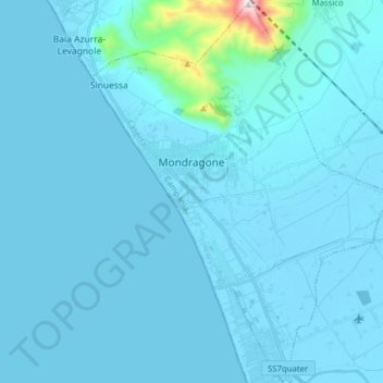
Name: Mondragone topographic map, elevation, terrain.

Location: Mondragone, Caserta, Campania, 81034, Italy (41.04586 13.85266 41.16410 13.98738)

Average elevation: 36 m

Minimum elevation: -2 m

Maximum elevation: 799 m

Other topographic maps

Click on a map to view its topography, its elevation and its terrain.

Monte Camino

Italy > Campania > Caserta > Rocca d'Evandro

Average elevation: 597 m

Destra Volturno

Italy > Campania > Caserta > Castel Volturno

Average elevation: 1 m

Campo Felice

Italy > Campania > Caserta > Cellole

Average elevation: 9 m

Cappelle

Italy > Campania > Caserta > Teano

Average elevation: 304 m

Località Aurno

Italy > Campania > Caserta > Marcianise

Average elevation: 22 m

Ventaroli

Italy > Campania > Caserta > Carinola

Average elevation: 156 m

Talanico

Italy > Campania > Caserta > San Felice a Cancello

Average elevation: 308 m

San Leucio-complex

Italy > Campania > Caserta > Caserta

Average elevation: 170 m

Brezza

Italy > Campania > Caserta

Average elevation: 13 m

Brezza

Italy > Campania > Caserta

Average elevation: 13 m