
Make a donation
Saint-Gaudens topographic map
Click on the map to display elevation.
Make a donation
Saint-Gaudens
Saint-Gaudens lies at an altitude of 405 m (1,329 ft) on a ledge overlooking the valley of the Garonne. It faces the Pyrenees and is a natural crossroads for routes between the Atlantic and the Mediterranean and between Toulouse and the Val d'Aran in Catalonia. Saint-Gaudens station has rail connections to Toulouse, Bayonne, Pau and Tarbes.
Make a donation
About this map
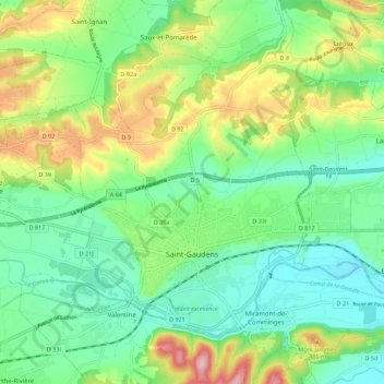
Name: Saint-Gaudens topographic map, elevation, terrain.
Average elevation: 404 m
Minimum elevation: 335 m
Maximum elevation: 547 m
Make a donation
Other topographic maps
Click on a map to view its topography, its elevation and its terrain.
Make a donation
Toulouse
France > Occitania > Haute-Garonne > Toulouse
The first half of the 14th century was a prosperous period, despite the dismemberment in 1317 of the very large bishopric of Toulouse (which lost two thirds of its area and a large part of its income, a loss only partially compensated by its elevation to the rank of archbishopric), and the episode of the…
Average elevation: 173 m