
Thank you for supporting this site ❤️
Make a donation
Make a donation
Schäfler topographic map
Click on the map to display elevation.
Thank you for supporting this site ❤️
Make a donation
Make a donation
Schäfler
謝弗勒山(德語:Schäfler),是瑞士的山峰,位於該國東北部,由內阿彭策爾州負責管轄,屬於阿爾卑斯坦山脈的一部分,距離阿爾特納普蒂姆山0.9公里,海拔高度1,925米。
Thank you for supporting this site ❤️
Make a donation
Make a donation
About this map
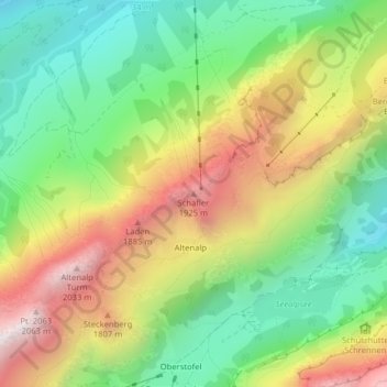
Name: Schäfler topographic map, elevation, terrain.
Location: Schäfler, Schwende-Rüte, Appenzell Innerrhoden, 9057, 瑞士 (47.27592 9.39040 47.27602 9.39050)
Average elevation: 1,424 m
Minimum elevation: 966 m
Maximum elevation: 2,054 m
Thank you for supporting this site ❤️
Make a donation
Make a donation
Other topographic maps
Click on a map to view its topography, its elevation and its terrain.
Seealpsee
瑞士 > Appenzell Innerrhoden > Schwende-Rüte
塞阿爾普湖(Seealpsee),是瑞士的湖泊,位於該國東北部,由內阿彭策爾州負責管轄,處於阿爾卑斯坦山脈,面積0.01平方公里,海拔高度1,143米,最大水深15米。
Average elevation: 1,492 m