
Make a donation
Alstead topographic map
Click on the map to display elevation.
Make a donation
About this map
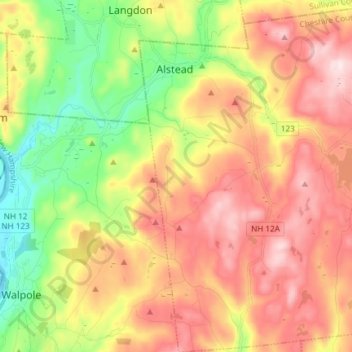
Name: Alstead topographic map, elevation, terrain.
Location: Alstead, Cheshire County, New Hampshire, United States (43.06179 -72.37642 43.16995 -72.24309)
Average elevation: 289 m
Minimum elevation: 64 m
Maximum elevation: 515 m
Make a donation
Other topographic maps
Click on a map to view its topography, its elevation and its terrain.
Stone Pond
United States > New Hampshire > Cheshire County > Marlow > Gee Mill
Average elevation: 430 m
Mount Monadnock
United States > New Hampshire > Cheshire County > Jaffrey
From the base to the summit, floral species diminish with increasingly shallow soil levels. The summit is home to many different specialized sub-alpine species which can retain moisture for long periods of time. Alpine and sub-alpine species include mountain ash, cotton grass, sheep laurel, mountain sandwort,…
Average elevation: 687 m
Make a donation
Camp Notre Dame
United States > New Hampshire > Cheshire County > Chesterfield
Average elevation: 223 m
Mount Monadnock
United States > New Hampshire > Cheshire County > Jaffrey
From the base to the summit, floral species diminish with increasingly shallow soil levels. The summit is home to many different specialized sub-alpine species which can retain moisture for long periods of time. Alpine and sub-alpine species include mountain ash, cotton grass, sheep laurel, mountain sandwort,…
Average elevation: 687 m
Make a donation
Mount Monadnock
United States > New Hampshire > Cheshire County > Jaffrey
From the base to the summit, floral species diminish with increasingly shallow soil levels. The summit is home to many different specialized sub-alpine species which can retain moisture for long periods of time. Alpine and sub-alpine species include mountain ash, cotton grass, sheep laurel, mountain sandwort,…
Average elevation: 687 m
Gilboa Mountain
United States > New Hampshire > Cheshire County > Westmoreland
Average elevation: 331 m
West Chesterfield
United States > New Hampshire > Cheshire County > Chesterfield
Average elevation: 168 m
Make a donation