
Thank you for supporting this site ❤️
Make a donation
Make a donation
Bohlenhagen topographic map
Click on the map to display elevation.
Thank you for supporting this site ❤️
Make a donation
Make a donation
Bohlenhagen
Bohlenhagen befindet sich auf dem Süd- und Osthang des Kissels. Dieser stellt zugleich auch die höchste an den Ort angrenzende Anhöhe dar. Im Süden wird das Dorf durch den Bohlenhagener Bach begrenzt. Der Ort liegt westlich des Stadtzentrums von Waldbröl.
Thank you for supporting this site ❤️
Make a donation
Make a donation
About this map
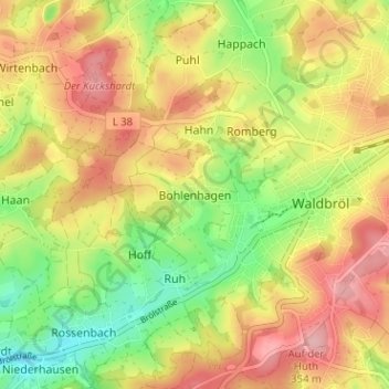
Name: Bohlenhagen topographic map, elevation, terrain.
Average elevation: 290 m
Minimum elevation: 218 m
Maximum elevation: 358 m
Thank you for supporting this site ❤️
Make a donation
Make a donation
Other topographic maps
Click on a map to view its topography, its elevation and its terrain.
Hermesdorf
Deutschland > Nordrhein-Westfalen > Oberbergischer Kreis > Waldbröl > Wilkenroth > Thierseifen
Average elevation: 299 m
51545
Deutschland > Nordrhein-Westfalen > Oberbergischer Kreis > Waldbröl > Romberg
Average elevation: 305 m