Geolocate

Diddams Close Park topographic map

Click on the map to display elevation.

About this map

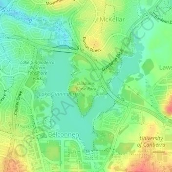
Name: Diddams Close Park topographic map, elevation, terrain.

Location: Diddams Close Park, Belconnen, District of Belconnen, Australian Capital Territory, 2617, Australia (-35.23313 149.06823 -35.22270 149.07632)

Average elevation: 589 m

Minimum elevation: 566 m

Maximum elevation: 625 m

Other topographic maps

Click on a map to view its topography, its elevation and its terrain.

Giralang

Australia > District of Belconnen

Average elevation: 601 m

Lawson

Australia > District of Belconnen

Average elevation: 597 m

Gossan Hill

Australia > District of Belconnen

Average elevation: 622 m

Mount Rogers

Australia > District of Belconnen

Mount Rogers is a large hill, with an elevation of 704 metres (2,310 ft), located in the northern suburbs of Canberra, within the Australian Capital Territory, Australia. There is a park called the Mount Rogers Reserve at the crest of the hill, and a trig point at the summit.

Average elevation: 620 m

Macnamara

Australia > District of Belconnen

Average elevation: 535 m

Macquarie

Australia > District of Belconnen

Average elevation: 622 m

McKellar

Australia > District of Belconnen

Average elevation: 593 m

Cook

Australia > District of Belconnen

Average elevation: 633 m

Charnwood

Australia > District of Belconnen

Average elevation: 588 m

Florey

Australia > District of Belconnen

Average elevation: 586 m

Melba

Australia > District of Belconnen

Average elevation: 599 m

Higgins

Australia > District of Belconnen

Average elevation: 598 m

Charnwood

Australia > District of Belconnen

Average elevation: 588 m

Holt

Australia > District of Belconnen

Average elevation: 581 m

Strathnairn

Australia > District of Belconnen

Average elevation: 551 m

Scullin

Australia > District of Belconnen

Average elevation: 604 m

Spence

Australia > District of Belconnen

Average elevation: 624 m

Fraser

Australia > District of Belconnen

Mount Rogers reserve is part of Fraser with an elevation of 704 metres (2,310 ft). Fraser has a neighbourhood oval and primary school. It is bordered to the north by Kuringa Drive.

Average elevation: 612 m