
Lakefield topographic map
Interactive map
Click on the map to display elevation.
About this map
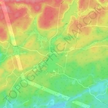
Name: Lakefield topographic map, elevation, terrain.
Location: Lakefield, Gore, Argenteuil, Laurentides, Québec, Canada (45.73113 -74.27625 45.77113 -74.23625)
Average elevation: 263 m
Minimum elevation: 198 m
Maximum elevation: 327 m
Other topographic maps
Click on a map to view its topography, its elevation and its terrain.
Lac Frédéric
Canada > Québec > Argenteuil > Gore
Lac Frédéric, Gore, Argenteuil, Laurentides, Québec, Canada
Average elevation: 251 m
Lac des Sucreries
Canada > Québec > Argenteuil > Gore
Lac des Sucreries, Grace Park, Gore, Argenteuil, Laurentides, Québec, Canada
Average elevation: 306 m