
Thank you for supporting this site ❤️
Make a donation
Make a donation
Tournepicque topographic map
Click on the map to display elevation.
Thank you for supporting this site ❤️
Make a donation
Make a donation
About this map
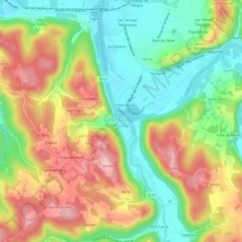
Name: Tournepicque topographic map, elevation, terrain.
Average elevation: 143 m
Minimum elevation: 58 m
Maximum elevation: 246 m
Thank you for supporting this site ❤️
Make a donation
Make a donation
Other topographic maps
Click on a map to view its topography, its elevation and its terrain.
Château des Milandes
France > Nouvelle-Aquitaine > Dordogne > Castelnaud-la-Chapelle
Average elevation: 110 m