
Argyll and Bute topographic map
Interactive map
Click on the map to display elevation.
About this map
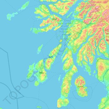
Name: Argyll and Bute topographic map, elevation, terrain.
Location: Argyll and Bute, Scotland, United Kingdom (55.27448 -7.11443 56.70508 -4.55985)
Average elevation: 84 m
Minimum elevation: -1 m
Maximum elevation: 1,105 m
Other topographic maps
Click on a map to view its topography, its elevation and its terrain.
Tigharry
United Kingdom > Scotland > Western Isles
Tigharry, Western Isles, Scotland, HS6 5DE, United Kingdom
Average elevation: 11 m
Lynwilg
United Kingdom > Scotland > Highland > Aviemore
Lynwilg, Aviemore, Highland, Scotland, PH22 1PZ, United Kingdom
Average elevation: 294 m
Dava
United Kingdom > Scotland > Moray
Dava, Moray, Scotland, PH26 3PU, United Kingdom
Average elevation: 305 m
Glasgow
United Kingdom > Scotland > Glasgow City
Glasgow, Glasgow City, Scotland, G2 1DY, United Kingdom
Average elevation: 128 m
City of Edinburgh
City of Edinburgh, Scotland, United Kingdom
Average elevation: 118 m
Cromarty
United Kingdom > Scotland > Highland
Cromarty, Highland, Scotland, IV11 8UZ, United Kingdom
Average elevation: 35 m
Kirkwall
United Kingdom > Scotland > Orkney Islands
Kirkwall, Orkney Islands, Scotland, KW15 1DH, United Kingdom
Average elevation: 27 m
Erraid
Erraid, Argyll and Bute, Scotland, United Kingdom
Average elevation: 8 m
Lanark
United Kingdom > Scotland > Lanark
Lanark, South Lanarkshire, Scotland, ML11, United Kingdom
Average elevation: 206 m
Caldervale
United Kingdom > Scotland > Uddingston
Caldervale, Uddingston, South Lanarkshire, Scotland, G71 7RN, United Kingdom
Average elevation: 33 m
Dumfries and Galloway
Dumfries and Galloway, Scotland, United Kingdom
Average elevation: 163 m
Newmains
United Kingdom > Scotland > Newmains
Newmains, North Lanarkshire, Scotland, ML2 9AX, United Kingdom
Average elevation: 163 m
Millbank
United Kingdom > Scotland > Millbank
Millbank, Aberdeenshire, Scotland, AB51 7RX, United Kingdom
Average elevation: 181 m
Westhill
United Kingdom > Scotland > Westhill
Westhill, Aberdeenshire, Scotland, United Kingdom
Average elevation: 141 m
North Connel
United Kingdom > Scotland > Argyll and Bute
North Connel, Argyll and Bute, Scotland, PA37 1PL, United Kingdom
Average elevation: 19 m
The Cour
The Cour, Highland, Scotland, PH34 4EY, United Kingdom
Average elevation: 337 m
Millport
United Kingdom > Scotland > Millport
Millport, North Ayrshire, Scotland, KA28 0BE, United Kingdom
Average elevation: 11 m
Achmore Farm
United Kingdom > Scotland > Achmore Farm
Achmore Farm, Highland, Scotland, IV27 4HL, United Kingdom
Average elevation: 250 m
Ben Nevis
Ben Nevis, Highland, Scotland, United Kingdom
Average elevation: 912 m
Cairnsmore of Fleet
Cairnsmore of Fleet, Dumfries and Galloway, Scotland, DG8 7BL, United Kingdom
Average elevation: 489 m
Hecla
Hecla, Na h-Eileanan Siar, Scotland, United Kingdom
Average elevation: 50 m
Spidean Coire nan Clach (Beinn Eighe)
Spidean Coire nan Clach (Beinn Eighe), Highland, Scotland, United Kingdom
Average elevation: 608 m
Lewis and Harris
Lewis and Harris, Na h-Eileanan Siar, Scotland, United Kingdom
Average elevation: 28 m
Islay
United Kingdom > Scotland > Argyll and Bute
Islay, Argyll and Bute, Scotland, United Kingdom
Average elevation: 53 m
Grampian Mountains
Grampian Mountains, Highland, Scotland, United Kingdom
Average elevation: 775 m
Port Glasgow
United Kingdom > Scotland > Port Glasgow
Port Glasgow, Inverclyde, Scotland, PA14 5JQ, United Kingdom
Average elevation: 83 m
Western Isles
Western Isles, Scotland, United Kingdom
Average elevation: 63 m
Muirhouse/Salvesen
United Kingdom > Scotland > Edinburgh
Muirhouse/Salvesen, Edinburgh, City of Edinburgh, Scotland, United Kingdom
Average elevation: 29 m
Fochabers
United Kingdom > Scotland > Fochabers
Fochabers, Moray, Scotland, IV32 7DG, United Kingdom
Average elevation: 60 m