
Thank you for supporting this site ❤️
Make a donation
Make a donation
Les Frasses topographic map
Click on the map to display elevation.
Thank you for supporting this site ❤️
Make a donation
Make a donation
About this map
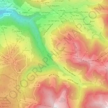
Name: Les Frasses topographic map, elevation, terrain.
Average elevation: 1,493 m
Minimum elevation: 983 m
Maximum elevation: 1,879 m
Thank you for supporting this site ❤️
Make a donation
Make a donation
Other topographic maps
Click on a map to view its topography, its elevation and its terrain.
Le Mont Rond
France > Auvergne-Rhône-Alpes > Savoie > Notre-Dame-de-Bellecombe
Average elevation: 1,533 m