
Make a donation
Le Tampon topographic map
Click on the map to display elevation.
Make a donation
Le Tampon
Le Tampon has an humid subtropical climate (Köppen climate classification: Cwa) at lower elevations and an oceanic climate (Köppen climate classification: Cfb) in Plains des Cafres. The average annual temperature in Le Tampon is 13.8 °C (56.8 °F). The average annual rainfall is 2,020.2 mm (79.54 in) with February as the wettest month. The temperatures are highest on average in February, at around 17.3 °C (63.1 °F), and lowest in July, at around 10.3 °C (50.5 °F). The highest temperature ever recorded in Le Tampon was 29.6 °C (85.3 °F) on 26 October 2011; the coldest temperature ever recorded was −1.7 °C (28.9 °F) on 18 August 1988.
Make a donation
About this map
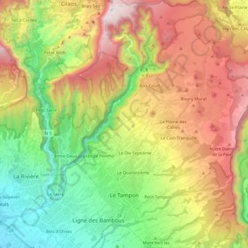
Name: Le Tampon topographic map, elevation, terrain.
Location: Le Tampon, Saint-Pierre, Réunion, France (-21.31661 55.47953 -21.13358 55.66070)
Average elevation: 1,005 m
Minimum elevation: 22 m
Maximum elevation: 2,345 m
Make a donation
Other topographic maps
Click on a map to view its topography, its elevation and its terrain.
Make a donation
Make a donation
Make a donation