
Thank you for supporting this site ❤️
Make a donation
Make a donation
Erawan topographic map
Click on the map to display elevation.
Thank you for supporting this site ❤️
Make a donation
Make a donation
About this map
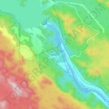
Name: Erawan topographic map, elevation, terrain.
Location: Erawan, Kanchanaburi Province, 71250, Thailand (14.34456 99.09609 14.42456 99.17609)
Average elevation: 348 m
Minimum elevation: 59 m
Maximum elevation: 859 m
Thank you for supporting this site ❤️
Make a donation
Make a donation
Other topographic maps
Click on a map to view its topography, its elevation and its terrain.