
Make a donation
Volos Municipality topographic map
Click on the map to display elevation.
Make a donation
About this map
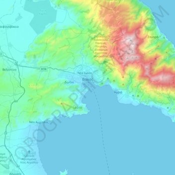
Name: Volos Municipality topographic map, elevation, terrain.
Average elevation: 228 m
Minimum elevation: -3 m
Maximum elevation: 1,604 m
Make a donation
Other topographic maps
Click on a map to view its topography, its elevation and its terrain.
Συκή
Greece > Thessaly > Regional Unit of Magnesia > Municipal Unit of Afetes
Average elevation: 220 m
Makrinitsa
Greece > Thessaly > Regional Unit of Magnesia > Volos Municipality
Average elevation: 663 m
Makrinitsa
Greece > Thessaly > Regional Unit of Magnesia > Volos Municipality
Average elevation: 663 m
Ζαγορά
Greece > Thessaly > Regional Unit of Magnesia > Municipal Unit of Zagora
Average elevation: 512 m
Make a donation
Makrinitsa
Greece > Thessaly > Regional Unit of Magnesia > Volos Municipality
Average elevation: 663 m
Ριζόμυλος
Greece > Thessaly > Regional Unit of Magnesia > Municipal Unit of Karla
Average elevation: 61 m