
Thank you for supporting this site ❤️
Make a donation
Make a donation
Pojorâta topographic map
Click on the map to display elevation.
Thank you for supporting this site ❤️
Make a donation
Make a donation
About this map
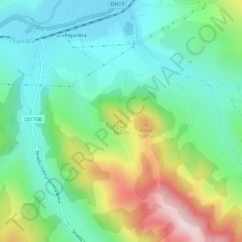
Name: Pojorâta topographic map, elevation, terrain.
Location: Pojorâta, Suceava, 727440, Romania, Eva (47.51496 25.48299 47.51506 25.48309)
Average elevation: 830 m
Minimum elevation: 684 m
Maximum elevation: 1,147 m
Thank you for supporting this site ❤️
Make a donation
Make a donation
Other topographic maps
Click on a map to view its topography, its elevation and its terrain.
Rădăuți
Rădăuți is situated in Bukovina, on a plain between the Suceava and Sucevița rivers, 37 km (23 mi) northwest from Suceava, the county capital. The city is located in the depression with the same name, at 375 metres (410 yards) altitude. It is one of the oldest settlements in Moldavia, known since the 15th…
Average elevation: 374 m