
Thank you for supporting this site ❤️
Make a donation
Make a donation
Twello topographic map
Click on the map to display elevation.
Thank you for supporting this site ❤️
Make a donation
Make a donation
About this map
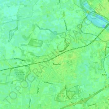
Name: Twello topographic map, elevation, terrain.
Location: Twello, Voorst, Gelderland, Netherlands (52.22075 6.05690 52.25985 6.14353)
Average elevation: 6 m
Minimum elevation: -4 m
Maximum elevation: 12 m
Thank you for supporting this site ❤️
Make a donation
Make a donation
Other topographic maps
Click on a map to view its topography, its elevation and its terrain.
Thank you for supporting this site ❤️
Make a donation
Make a donation
Thank you for supporting this site ❤️
Make a donation
Make a donation
Thank you for supporting this site ❤️
Make a donation
Make a donation