
Thank you for supporting this site ❤️
Make a donation
Make a donation
Machachi topographic map
Click on the map to display elevation.
Thank you for supporting this site ❤️
Make a donation
Make a donation
Machachi
Machachi is located to the south of the capital of Ecuador, Quito. It is a city surrounded by the volcanos Atacazo, Corazon, Rumiñahui, Illinizas Peaks, Viudita Hill, Pasochoa, and Sincholagua, and owns part of the Cotopaxi volcano, a great active volcano which measures 5,897 m (19,347 ft) in altitude. In fact, the valley owns eight volcanoes inside, one the reasons Alexander von Humboldt named the region "Avenue of Volcanoes".
Thank you for supporting this site ❤️
Make a donation
Make a donation
About this map
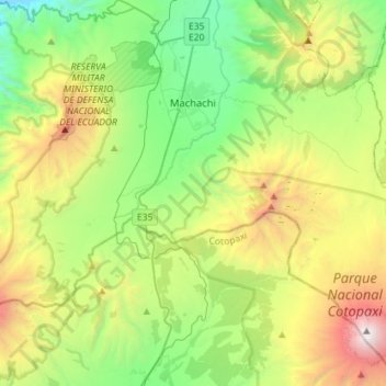
Name: Machachi topographic map, elevation, terrain.
Location: Machachi, Pichincha, Ecuador (-0.72106 -78.60579 -0.43621 -78.32060)
Average elevation: 3,542 m
Minimum elevation: 2,398 m
Maximum elevation: 5,853 m
Thank you for supporting this site ❤️
Make a donation
Make a donation
Other topographic maps
Click on a map to view its topography, its elevation and its terrain.