
Make a donation
Gura Humorului topographic map
Click on the map to display elevation.
Make a donation
Gura Humorului
Gura Humorului is located in the north-eastern part of Romania, in southern Bukovina. The town is situated at the eastern limit of Obcinele Bucovinei Mountains, in Humorului Depression, at the confluence of Moldova River and Humor River. The average altitude of the town is 470 metres (1,540 ft). The European route E58 and the Suceava–Vatra Dornei railway pass through the town. Suceava, the county capital, is located 34 kilometres (21 miles) away. The town of Frasin is located nearby Gura Humorului (only 7 km (4.3 mi) away).
Make a donation
About this map
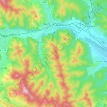
Name: Gura Humorului topographic map, elevation, terrain.
Location: Gura Humorului, Suceava, Romania (47.45287 25.82307 47.58245 25.95007)
Average elevation: 644 m
Minimum elevation: 433 m
Maximum elevation: 1,070 m
Make a donation
Other topographic maps
Click on a map to view its topography, its elevation and its terrain.
Make a donation
Make a donation
Make a donation
Make a donation