
Make a donation
Bi'r Qa`wah topographic map
Click on the map to display elevation.
Make a donation
About this map
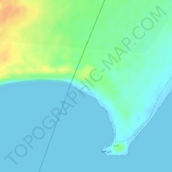
Name: Bi'r Qa`wah topographic map, elevation, terrain.
Location: Bi'r Qa`wah, Al Boraygah District, Aden Governorate, Yemen (12.68038 44.41223 12.68048 44.41233)
Average elevation: 10 m
Minimum elevation: -1 m
Maximum elevation: 39 m
Make a donation
Other topographic maps
Click on a map to view its topography, its elevation and its terrain.
Aden City
Aden is located on the coast of the Gulf of Aden, and is about 363 kilometers away from the capital, Sana’a. It is located between latitudes 47 and 12 north of the equator, and at an altitude of 6 meters above sea level. It is surrounded by Lahj Governorate to the north and east, and the Governorate of Abyan…
Average elevation: 11 m
Aden City
Aden is located on the coast of the Gulf of Aden, and is about 363 kilometres from the capital, Sanaa. It is located between latitudes 47 and 12 north of the equator, and at an altitude of 6 metres above sea level. It is surrounded by Lahj Governorate to the north and east, and the Governorate of Abyan is to…
Average elevation: 11 m
Aden City
Aden is located on the coast of the Gulf of Aden, and is about 363 kilometers away from the capital, Sana’a. It is located between latitudes 47 and 12 north of the equator, and at an altitude of 6 meters above sea level. It is surrounded by Lahj Governorate to the north and east, and the Governorate of Abyan…
Average elevation: 11 m
Make a donation
Make a donation