
Guangzhou City topographic map
Interactive map
Click on the map to display elevation.
About this map
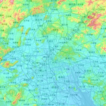
Name: Guangzhou City topographic map, elevation, terrain.
Location: Guangzhou City, Guangdong Province, China (22.56080 112.95237 23.93566 114.05476)
Average elevation: 98 m
Minimum elevation: -10 m
Maximum elevation: 1,236 m
The elevation of the prefecture generally increases from southwest to northeast, with mountains forming the backbone of the city and the ocean comprising the front. Tiantang Peak (天堂顶, "Heavenly Peak") is the highest point of elevation at 1,210 metres (3,970 ft) above sea level.
Other topographic maps
Click on a map to view its topography, its elevation and its terrain.
Bao'an District
Bao'an District, Shenzhen, Guangdong Province, 518100, China
Average elevation: 36 m
Xinxing
China > Guangdong Province > Xinxing County > Xincheng
Xinxing, Xincheng, Xinxing County, Yunfu City, Guangdong Province, 527400, China
Average elevation: 153 m
Zhanjiang City
Zhanjiang City, Guangdong Province, China
Average elevation: 23 m
Conghua District
Conghua District, Guangdong Province, China
Average elevation: 184 m