
Shantou topographic map
Interactive map
Click on the map to display elevation.
About this map
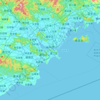
Name: Shantou topographic map, elevation, terrain.
Location: Shantou, Guangdong Province, China (22.98757 116.24004 23.64845 117.41973)
Average elevation: 55 m
Minimum elevation: -2 m
Maximum elevation: 1,233 m
Other topographic maps
Click on a map to view its topography, its elevation and its terrain.
Bao'an District
Bao'an District, Shenzhen, Guangdong Province, 518100, China
Average elevation: 36 m
Xinxing
China > Guangdong Province > Xinxing County > Xincheng
Xinxing, Xincheng, Xinxing County, Yunfu City, Guangdong Province, 527400, China
Average elevation: 153 m
Zhanjiang City
Zhanjiang City, Guangdong Province, China
Average elevation: 23 m
Conghua District
Conghua District, Guangdong Province, China
Average elevation: 184 m
Guangzhou City
Guangzhou City, Guangdong Province, China
Average elevation: 98 m