
Exbomont topographic map
Interactive map
Click on the map to display elevation.
About this map
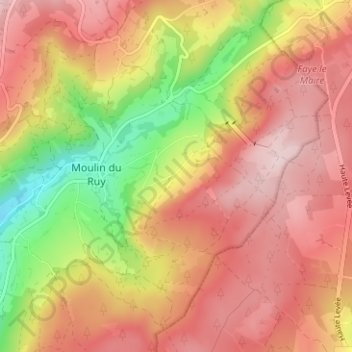
Name: Exbomont topographic map, elevation, terrain.
Location: Exbomont, Stoumont, Verviers, Liège, Wallonie, 4987, Belgique (50.40421 5.88102 50.44421 5.92102)
Average elevation: 420 m
Minimum elevation: 240 m
Maximum elevation: 541 m
Other topographic maps
Click on a map to view its topography, its elevation and its terrain.
Borgoumont
Belgique > Liège > Verviers > Stoumont
Borgoumont, Stoumont, Verviers, Liège, Wallonie, 4987, Belgique
Average elevation: 398 m
Xhierfomont
Belgique > Liège > Verviers > Stoumont
Xhierfomont, Stoumont, Verviers, Liège, Wallonie, 4987, Belgique
Average elevation: 295 m
Château de Froidcourt
Belgique > Liège > Verviers > Stoumont
Château de Froidcourt, 8, Froidcour, Stoumont, Verviers, Liège, Wallonie, 4987, Belgique
Average elevation: 317 m
Grimbiémont
Belgique > Liège > Verviers > Stoumont
Grimbiémont, Stoumont, Verviers, Liège, Wallonie, 4987, Belgique
Average elevation: 345 m