
Thank you for supporting this site ❤️
Make a donation
Make a donation
Mavrovo topographic map
Click on the map to display elevation.
Thank you for supporting this site ❤️
Make a donation
Make a donation
About this map
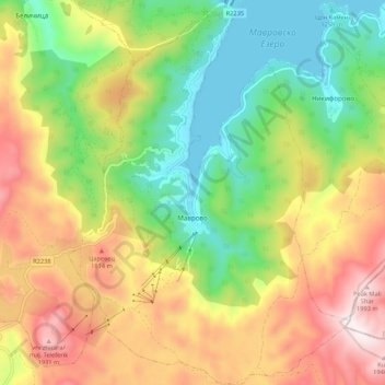
Name: Mavrovo topographic map, elevation, terrain.
Location: Mavrovo, Municipality of Mavrovo and Rostusha, North Macedonia (41.61682 20.70120 41.69678 20.77969)
Average elevation: 1,553 m
Minimum elevation: 1,217 m
Maximum elevation: 1,988 m
Thank you for supporting this site ❤️
Make a donation
Make a donation
Other topographic maps
Click on a map to view its topography, its elevation and its terrain.
Ohrid
North Macedonia > Southwestern Region > Ohrid
Ohrid is located in the south-western part of North Macedonia, on the shore of Lake Ohrid, at an elevation of 695 meters above sea level.
Average elevation: 963 m
Thank you for supporting this site ❤️
Make a donation
Make a donation
Thank you for supporting this site ❤️
Make a donation
Make a donation
Thank you for supporting this site ❤️
Make a donation
Make a donation
Thank you for supporting this site ❤️
Make a donation
Make a donation
Thank you for supporting this site ❤️
Make a donation
Make a donation