
Thank you for supporting this site ❤️
Make a donation
Make a donation
City Creek topographic map
Click on the map to display elevation.
Thank you for supporting this site ❤️
Make a donation
Make a donation
About this map
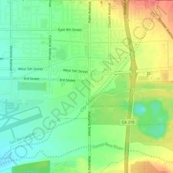
Name: City Creek topographic map, elevation, terrain.
Average elevation: 363 m
Minimum elevation: 337 m
Maximum elevation: 400 m
Thank you for supporting this site ❤️
Make a donation
Make a donation
Other topographic maps
Click on a map to view its topography, its elevation and its terrain.
Devil Canyon
United States > California > San Bernardino County > San Bernardino
Average elevation: 628 m
Devil Canyon
United States > California > San Bernardino County > San Bernardino
Average elevation: 628 m