
Thank you for supporting this site ❤️
Make a donation
Make a donation
Felbecke topographic map
Click on the map to display elevation.
Thank you for supporting this site ❤️
Make a donation
Make a donation
Felbecke
Das Dorf liegt rund 2 km westlich von Wormbach in einer Höhe von 393 – 400 m über NN. Durch Felbecke führt die Landesstraße 737 und fließt der Bach Werde. Um das Dorf liegt das Landschaftsschutzgebiet Offenlandkomplex Werntrop/Selkentrop/Felbecke.
Thank you for supporting this site ❤️
Make a donation
Make a donation
About this map
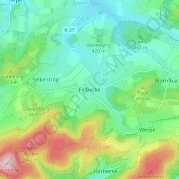
Name: Felbecke topographic map, elevation, terrain.
Average elevation: 449 m
Minimum elevation: 349 m
Maximum elevation: 678 m
Thank you for supporting this site ❤️
Make a donation
Make a donation
Other topographic maps
Click on a map to view its topography, its elevation and its terrain.
Esenbeck
Deutschland > Nordrhein-Westfalen > Hochsauerlandkreis > Schmallenberg > Obersorpe
Average elevation: 687 m