
Thank you for supporting this site ❤️
Make a donation
Make a donation
Havay topographic map
Click on the map to display elevation.
Thank you for supporting this site ❤️
Make a donation
Make a donation
About this map
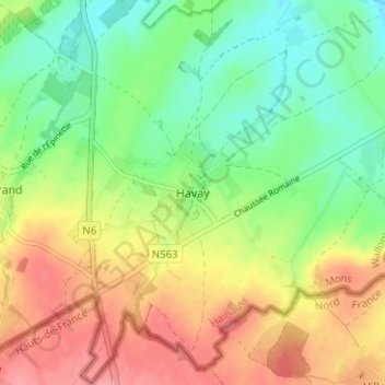
Name: Havay topographic map, elevation, terrain.
Location: Havay, Quévy, Mons, Hainaut, Wallonie, 7041, Belgique (50.34054 3.96396 50.38054 4.00396)
Average elevation: 94 m
Minimum elevation: 55 m
Maximum elevation: 142 m
Thank you for supporting this site ❤️
Make a donation
Make a donation
Other topographic maps
Click on a map to view its topography, its elevation and its terrain.
Thank you for supporting this site ❤️
Make a donation
Make a donation