
Sugiez topographic map
Interactive map
Click on the map to display elevation.
About this map
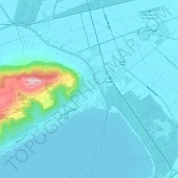
Name: Sugiez topographic map, elevation, terrain.
Location: Sugiez, Mont-Vully, District du Lac, Fribourg, 1786, Suisse (46.94175 7.09265 46.98175 7.13265)
Average elevation: 447 m
Minimum elevation: 423 m
Maximum elevation: 654 m
Other topographic maps
Click on a map to view its topography, its elevation and its terrain.
Mont-Vully
Suisse > Fribourg > District du Lac > Mont-Vully
Mont-Vully, District du Lac, Fribourg, Suisse
Average elevation: 449 m