
Make a donation
Kampung Padang topographic map
Click on the map to display elevation.
Make a donation
About this map
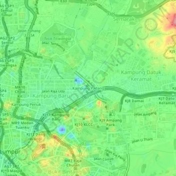
Name: Kampung Padang topographic map, elevation, terrain.
Location: Kampung Padang, Kampung Bharu, Kuala Lumpur, 50572, Malaysia (3.14607 101.69393 3.18607 101.73393)
Average elevation: 46 m
Minimum elevation: -52 m
Maximum elevation: 127 m
Make a donation
Other topographic maps
Click on a map to view its topography, its elevation and its terrain.
KLCC Park
Malaysia > Kuala Lumpur > Kuala Lumpur
The park was designed to showcase a heritage of tropical greenery by integrating man's creation with nature. The park itself contrasts as a calm environment in the midst of the hustle and bustle of the city. The park features many combinations of man-made design such as cements, water features and also natural…
Average elevation: 46 m
Make a donation
Kiara Hills Federal Park Family Recreation Zone
Malaysia > Kuala Lumpur > Kuala Lumpur
Average elevation: 81 m
Make a donation