
Thank you for supporting this site ❤️
Make a donation
Make a donation
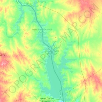
Falcon International Reservoir topographic map
Click on the map to display elevation.
Thank you for supporting this site ❤️
Make a donation
Make a donation
Falcon International Reservoir
Climate data is recorded near the southeast corner of the reservoir at 26°33′29″N 99°08′14″W / 26.5580°N 99.1372°W / 26.5580; -99.1372 and an elevation of 97.5 metres (320 ft).
Thank you for supporting this site ❤️
Make a donation
Make a donation
About this map
Name: Falcon International Reservoir topographic map, elevation, terrain.
Average elevation: 110 m
Minimum elevation: 70 m
Maximum elevation: 185 m
Thank you for supporting this site ❤️
Make a donation
Make a donation