
Thank you for supporting this site ❤️
Make a donation
Make a donation
Coal Hill topographic map
Click on the map to display elevation.
Thank you for supporting this site ❤️
Make a donation
Make a donation
About this map
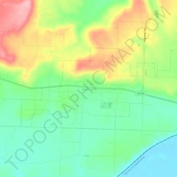
Name: Coal Hill topographic map, elevation, terrain.
Location: Coal Hill, Johnson County, Arkansas, 72832, United States (35.42639 -93.69531 35.44846 -93.63684)
Average elevation: 163 m
Minimum elevation: 104 m
Maximum elevation: 254 m
Thank you for supporting this site ❤️
Make a donation
Make a donation
Other topographic maps
Click on a map to view its topography, its elevation and its terrain.