
Tourém topographic map
Interactive map
Click on the map to display elevation.
About this map
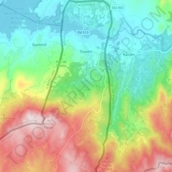
Name: Tourém topographic map, elevation, terrain.
Location: Tourém, Montalegre, Vila Real, Portugal (41.85881 -7.92130 41.92710 -7.88372)
Average elevation: 1,026 m
Minimum elevation: 816 m
Maximum elevation: 1,390 m
Other topographic maps
Click on a map to view its topography, its elevation and its terrain.
Castanheiro
Portugal > Vila Real > Montalegre
Castanheiro, Montalegre, Vila Real, Portugal
Average elevation: 1,082 m
Rio Rabagão
Portugal > Vila Real > Montalegre > Chã
Rio Rabagão, Chã, Montalegre, Vila Real, 5470-071, Portugal
Average elevation: 898 m