
Make a donation
Penticton topographic map
Click on the map to display elevation.
Make a donation
Penticton
Penticton is located at the geographical coordinates of 49°29′28″N 119°35′19″W / 49.49111°N 119.58861°W / 49.49111; -119.58861 (Penticton) and covers an area of 42.10 km2 (16.25 sq mi), with a maximum north–south distance of 7 km (4.3 mi) wide between the Okanagan Lake to the north and Skaha Lake to the south; these lakes are part of the drainage system of the Okanagan River, a tributary of the Columbia River. Its borders are formed by Skaha Lake Road to the south and west, which changes to Highway 97 after city limits, Naramata Road to the east, and to the west, Highway 97. Penticton has an elevation of 385 m (1,263 ft), and is situated five hours from Seattle, Washington, and Vancouver, British Columbia in another direction; and eight hours from Calgary, Alberta, by highway.
Make a donation
About this map
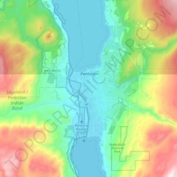
Name: Penticton topographic map, elevation, terrain.
Average elevation: 702 m
Minimum elevation: 334 m
Maximum elevation: 1,530 m
Make a donation