
Thank you for supporting this site ❤️
Make a donation
Make a donation
Beacon Hill topographic map
Click on the map to display elevation.
Thank you for supporting this site ❤️
Make a donation
Make a donation
About this map
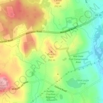
Name: Beacon Hill topographic map, elevation, terrain.
Average elevation: 229 m
Minimum elevation: 167 m
Maximum elevation: 301 m
Thank you for supporting this site ❤️
Make a donation
Make a donation
Other topographic maps
Click on a map to view its topography, its elevation and its terrain.
South Charlton Reservoir
United States > Massachusetts > Worcester County > Charlton > South Charlton
Average elevation: 203 m