
Thank you for supporting this site ❤️
Make a donation
Make a donation
Ciudad Reformadores topographic map
Click on the map to display elevation.
Thank you for supporting this site ❤️
Make a donation
Make a donation
About this map
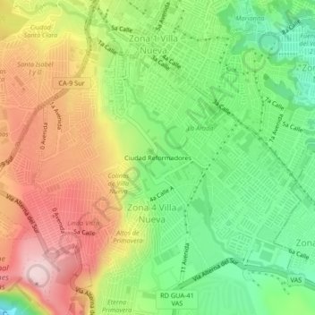
Name: Ciudad Reformadores topographic map, elevation, terrain.
Average elevation: 1,353 m
Minimum elevation: 1,191 m
Maximum elevation: 1,548 m
Thank you for supporting this site ❤️
Make a donation
Make a donation
Other topographic maps
Click on a map to view its topography, its elevation and its terrain.
Thank you for supporting this site ❤️
Make a donation
Make a donation
Zona 11 de Villa Nueva
Guatemala > Departamento de Guatemala > Villa Nueva > Zona 11 de Villa Nueva
Average elevation: 1,415 m
Thank you for supporting this site ❤️
Make a donation
Make a donation
Thank you for supporting this site ❤️
Make a donation
Make a donation
Thank you for supporting this site ❤️
Make a donation
Make a donation