
Thank you for supporting this site ❤️
Make a donation
Make a donation
Jawa Laut topographic map
Click on the map to display elevation.
Thank you for supporting this site ❤️
Make a donation
Make a donation
About this map
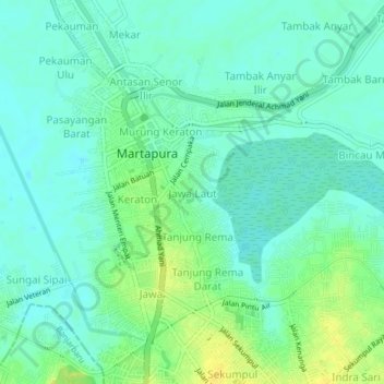
Name: Jawa Laut topographic map, elevation, terrain.
Location: Jawa Laut, Banjar, South Kalimantan, 71213, Indonesia (-3.43276 114.83358 -3.39276 114.87358)
Average elevation: 9 m
Minimum elevation: 1 m
Maximum elevation: 23 m
Thank you for supporting this site ❤️
Make a donation
Make a donation
Other topographic maps
Click on a map to view its topography, its elevation and its terrain.