
Thank you for supporting this site ❤️
Make a donation
Make a donation
Hours topographic map
Click on the map to display elevation.
Thank you for supporting this site ❤️
Make a donation
Make a donation
About this map
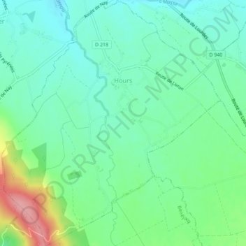
Name: Hours topographic map, elevation, terrain.
Average elevation: 333 m
Minimum elevation: 300 m
Maximum elevation: 416 m
Thank you for supporting this site ❤️
Make a donation
Make a donation
Other topographic maps
Click on a map to view its topography, its elevation and its terrain.
Les Eschartès
France > Nouvelle-Aquitaine > Pyrénées-Atlantiques > Louvie-Soubiron
Average elevation: 942 m