
Thank you for supporting this site ❤️
Make a donation
Make a donation
Katzelsdorf topographic map
Click on the map to display elevation.
Thank you for supporting this site ❤️
Make a donation
Make a donation
About this map
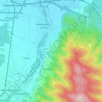
Name: Katzelsdorf topographic map, elevation, terrain.
Average elevation: 354 m
Minimum elevation: 267 m
Maximum elevation: 621 m
Thank you for supporting this site ❤️
Make a donation
Make a donation
Other topographic maps
Click on a map to view its topography, its elevation and its terrain.
Völlerinquelle
Austria > Lower Austria > Bezirk Wiener Neustadt > Gemeinde Hohe Wand > Maiersdorf
Average elevation: 737 m
Gaaden
Austria > Lower Austria > Bezirk Wiener Neustadt > Gemeinde Hohe Wand > Gaaden
Average elevation: 480 m