
Donzère topographic map
Click on the map to display elevation.
About this map
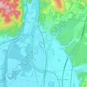
Name: Donzère topographic map, elevation, terrain.
Average elevation: 105 m
Minimum elevation: 48 m
Maximum elevation: 396 m
Other topographic maps
Click on a map to view its topography, its elevation and its terrain.
Valence
France > Auvergne-Rhône-Alpes > Drôme
The area of the commune is 3,669 hectares (9,070 acres), representing 36.69 square kilometres (14.17 sq mi); the altitude varies between 106–191 metres (348–627 ft).
Average elevation: 287 m