
Thank you for supporting this site ❤️
Make a donation
Make a donation
Gartnerkofel topographic map
Click on the map to display elevation.
Thank you for supporting this site ❤️
Make a donation
Make a donation
About this map
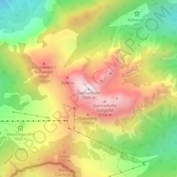
Name: Gartnerkofel topographic map, elevation, terrain.
Average elevation: 1,705 m
Minimum elevation: 1,249 m
Maximum elevation: 2,174 m
Thank you for supporting this site ❤️
Make a donation
Make a donation
Other topographic maps
Click on a map to view its topography, its elevation and its terrain.
Lake Pressegg
Austria > Carinthia > Bezirk Hermagor > Hermagor-Pressegger See > Presseggersee > Paßriach
Average elevation: 627 m