
Thank you for supporting this site ❤️
Make a donation
Make a donation
Bougnies topographic map
Click on the map to display elevation.
Thank you for supporting this site ❤️
Make a donation
Make a donation
About this map
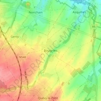
Name: Bougnies topographic map, elevation, terrain.
Location: Bougnies, Quévy, Mons, Hainaut, Wallonie, 7040, Belgique (50.36675 3.91917 50.40675 3.95917)
Average elevation: 86 m
Minimum elevation: 46 m
Maximum elevation: 126 m
Thank you for supporting this site ❤️
Make a donation
Make a donation
Other topographic maps
Click on a map to view its topography, its elevation and its terrain.
Thank you for supporting this site ❤️
Make a donation
Make a donation