
Inzersdorf im Kremstal topographic map
Interactive map
Click on the map to display elevation.
About this map
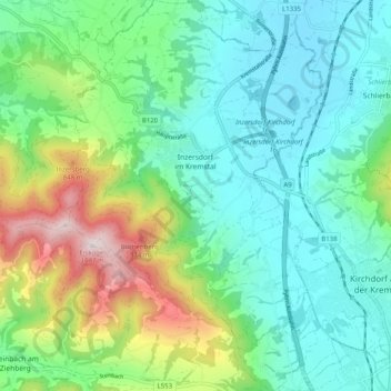
Name: Inzersdorf im Kremstal topographic map, elevation, terrain.
Location: Inzersdorf im Kremstal, Bezirk Kirchdorf, 4565, Österreich (47.88672 14.04514 47.95425 14.11114)
Average elevation: 570 m
Minimum elevation: 387 m
Maximum elevation: 1,074 m
Other topographic maps
Click on a map to view its topography, its elevation and its terrain.
Ramsau
Österreich > Bezirk Kirchdorf > Molln
Ramsau, Molln, Bezirk Kirchdorf, 4591, Österreich
Average elevation: 769 m
Steinbach an der Steyr
Steinbach an der Steyr, Bezirk Kirchdorf, 4596, Österreich
Average elevation: 543 m
Hiersdorf
Österreich > Bezirk Kirchdorf > Wartberg an der Krems
Hiersdorf, Wartberg an der Krems, Bezirk Kirchdorf, 4552, Österreich
Average elevation: 472 m
Kremsmünster
Kremsmünster, Bezirk Kirchdorf, 4550, Österreich
Average elevation: 403 m
Windischgarsten
Windischgarsten, Bezirk Kirchdorf, 4580, Österreich
Average elevation: 660 m
Hinterstoder
Hinterstoder, Bezirk Kirchdorf, 4573, Österreich
Average elevation: 1,283 m