
Thank you for supporting this site ❤️
Make a donation
Make a donation
Saint-Polgues topographic map
Click on the map to display elevation.
Thank you for supporting this site ❤️
Make a donation
Make a donation
About this map
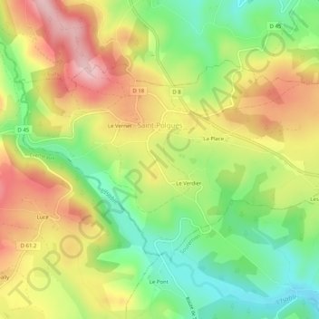
Name: Saint-Polgues topographic map, elevation, terrain.
Average elevation: 536 m
Minimum elevation: 430 m
Maximum elevation: 653 m
Thank you for supporting this site ❤️
Make a donation
Make a donation
Other topographic maps
Click on a map to view its topography, its elevation and its terrain.
Thank you for supporting this site ❤️
Make a donation
Make a donation
Valiant
France > Auvergne-Rhône-Alpes > Loire > Saint-Bonnet-des-Quarts > Le Royer
Average elevation: 623 m
Thank you for supporting this site ❤️
Make a donation
Make a donation
Thank you for supporting this site ❤️
Make a donation
Make a donation
Le Marthoret
France > Auvergne-Rhône-Alpes > Loire > Rive-de-Gier > Le Marthoret
Average elevation: 317 m
Thank you for supporting this site ❤️
Make a donation
Make a donation