
Thank you for supporting this site ❤️
Make a donation
Make a donation
Sharjah topographic map
Click on the map to display elevation.
Thank you for supporting this site ❤️
Make a donation
Make a donation
About this map
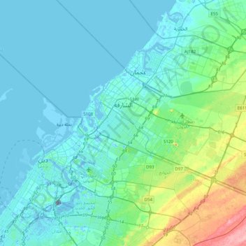
Name: Sharjah topographic map, elevation, terrain.
Location: Sharjah, Sharjah Emirate, United Arab Emirates (25.20718 55.34907 25.43208 55.74346)
Average elevation: 19 m
Minimum elevation: -14 m
Maximum elevation: 127 m
Thank you for supporting this site ❤️
Make a donation
Make a donation