
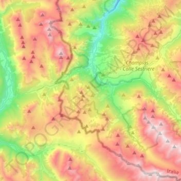
Cesana Torinese topographic map
Interactive map
Click on the map to display elevation.
About this map
Name: Cesana Torinese topographic map, elevation, terrain.
Location: Cesana Torinese, Turin, Piemont, 10054, Italien (44.84328 6.73735 45.01448 6.93142)
Average elevation: 2,120 m
Minimum elevation: 1,145 m
Maximum elevation: 3,280 m
Der Ort liegt auf einer Höhe von 1354 m über dem Meeresspiegel am Zusammenfluss der Gebirgsbäche Ripa und Dora zur Dora Riparia. Das Gemeindegebiet umfasst eine Fläche von 121,3 km² und hat 913 Einwohner (Stand 31. Dezember 2022). Die Gemeinde besteht aus den Ortsteilen Bousson, Désertes, Fénils, Mollières, Solomiac, Thures, Champlas Seguin, Rhuilles, San Sicario Borgo, San Sicario Alto und Pra Claud.
Other topographic maps
Click on a map to view its topography, its elevation and its terrain.
Sauze d'Oulx
Sauze d'Oulx, Turin, Piemont, Italien
Average elevation: 1,714 m