
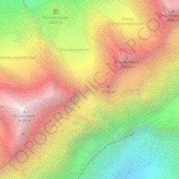
Fründenjoch topographic map
Interactive map
Click on the map to display elevation.
About this map
Name: Fründenjoch topographic map, elevation, terrain.
Average elevation: 2,757 m
Minimum elevation: 1,800 m
Maximum elevation: 3,627 m
Other topographic maps
Click on a map to view its topography, its elevation and its terrain.
Morgenhorn
Schweiz > Bern > Kandersteg
Morgenhorn, Kandersteg, Verwaltungskreis Frutigen-Niedersimmental, Verwaltungsregion Oberland, Bern, 3718, Schweiz
Average elevation: 2,923 m
Doldenhorn
Schweiz > Bern > Kandersteg
Doldenhorn, Kandersteg, Verwaltungskreis Frutigen-Niedersimmental, Verwaltungsregion Oberland, Bern, 3718, Schweiz
Average elevation: 2,802 m
Oeschinenhorn
Schweiz > Bern > Kandersteg
Oeschinenhorn, Kandersteg, Verwaltungskreis Frutigen-Niedersimmental, Verwaltungsregion Oberland, Bern, 3718, Schweiz
Average elevation: 2,934 m
Blümlisalphorn
Schweiz > Bern > Kandersteg
Blümlisalphorn, Kandersteg, Verwaltungskreis Frutigen-Niedersimmental, Verwaltungsregion Oberland, Bern, 3718, Schweiz
Average elevation: 3,010 m
Altels
Schweiz > Bern > Kandersteg
Altels, Kandersteg, Verwaltungskreis Frutigen-Niedersimmental, Verwaltungsregion Oberland, Bern, 3718, Schweiz
Average elevation: 2,973 m
Balmhorn
Schweiz > Bern > Kandersteg
Balmhorn, Kandersteg, Verwaltungskreis Frutigen-Niedersimmental, Verwaltungsregion Oberland, Bern, 3718, Schweiz
Average elevation: 2,955 m