
Thank you for supporting this site ❤️
Make a donation
Make a donation
Anzoategui State topographic map
Click on the map to display elevation.
Thank you for supporting this site ❤️
Make a donation
Make a donation
Anzoategui State
The vegetation of the Anzoátegui State is typical temperate. It is largely determined by altitude, climate and season of the year, where areas of snow-covered scrub, cujíes and small southern species alternate. It also has a tree called caderoms, this includes resistant or environmentally adapted varieties.
Thank you for supporting this site ❤️
Make a donation
Make a donation
About this map
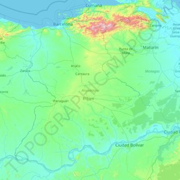
Name: Anzoategui State topographic map, elevation, terrain.
Location: Anzoategui State, Venezuela (7.66544 -65.75103 10.37411 -62.68819)
Average elevation: 156 m
Minimum elevation: -1 m
Maximum elevation: 2,431 m
Thank you for supporting this site ❤️
Make a donation
Make a donation
Other topographic maps
Click on a map to view its topography, its elevation and its terrain.
Thank you for supporting this site ❤️
Make a donation
Make a donation
Valencia
Venezuela > Carabobo State > Municipio Valencia
The elevation of the city is 520 metres (1,710 feet).
Average elevation: 600 m
Thank you for supporting this site ❤️
Make a donation
Make a donation