
Make a donation
Espírito Santo topographic map
Click on the map to display elevation.
Make a donation
Espírito Santo
The Captaincy of Espírito Santo was carved out of the Captaincy of Bahia in the 18th century, during the colonial rule of Brazil, and named after a 16th-century captaincy covering roughly the same area of coast. Following the elevation of Brazil to a constituent kingdom of United Kingdom of Portugal, Brazil and the Algarves in 1815, prompted by the transfer of the Portuguese Court to Brazil, Espírito Santo was elevated to a province. After the independence of Brazil in 1822, it became a province of the newly established Empire of Brazil, and after Brazil became a republic in 1889, it was granted statehood. In the early 20th century, its current state symbols were adopted.
Make a donation
About this map
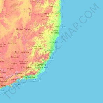
Name: Espírito Santo topographic map, elevation, terrain.
Location: Espírito Santo, Southeast Region, Brazil (-21.43393 -41.87981 -17.89195 -28.62896)
Average elevation: 265 m
Minimum elevation: -1 m
Maximum elevation: 2,500 m
Make a donation
Other topographic maps
Click on a map to view its topography, its elevation and its terrain.
Brasília
Brazil > Federal District > Região Integrada de Desenvolvimento do Distrito Federal e Entorno
The city sits at an elevation of 1,000 metres (3,300 ft) and more, high on the Brazilian Highlands in the country's center-western region. Paranoá Lake, a large artificial lake, was built to increase the amount of water available and to maintain the region's humidity. It has a marina, and hosts wakeboarders…
Average elevation: 1,084 m
Sugarloaf
Brazil > Rio de Janeiro > Região Metropolitana do Rio de Janeiro > Rio de Janeiro
Average elevation: 17 m
Make a donation
Make a donation
Pelotas
Brazil > Rio Grande do Sul > Aglomeração Urbana do Sul > Pelotas
As it is situated on a plain near the ocean, the urban area lies on a low elevation, being, on average, 7 meters (23 ft) above sea level. The interior of the municipality is on a plateau called Serras de Sudeste (Southeastern Mountain Ranges). Consequently, the altitude in Pelotas' rural area reaches 429…
Average elevation: 18 m
Make a donation
Make a donation
Petrópolis
Brazil > Rio de Janeiro > Região Metropolitana do Rio de Janeiro > Petrópolis
Average elevation: 683 m
Ilha do Búzio
Brazil > Pernambuco > Região Metropolitana do Recife > Ilha de Itamaracá
Average elevation: 7 m
Make a donation