
Thank you for supporting this site ❤️
Make a donation
Make a donation
Ikaluit topographic map
Click on the map to display elevation.
Thank you for supporting this site ❤️
Make a donation
Make a donation
About this map
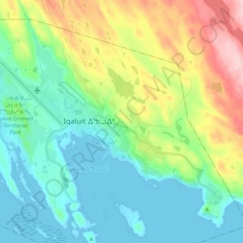
Name: Ikaluit topographic map, elevation, terrain.
Location: Ikaluit, Iqaluit, ᐃᖃᓗᐃᑦ, Qikiqtaaluk Region, Nunavut, Canada (63.72181 -68.57950 63.77627 -68.43337)
Average elevation: 74 m
Minimum elevation: -1 m
Maximum elevation: 260 m
Thank you for supporting this site ❤️
Make a donation
Make a donation
Other topographic maps
Click on a map to view its topography, its elevation and its terrain.
Iqaluit
Iqaluit has a tundra climate (Köppen: ET) typical of the Arctic region, although it is well outside the Arctic Circle. The city features long, cold winters and brief, cool summers. Average monthly temperatures are below freezing for eight months of the year. Iqaluit averages just over 400 mm (16 in) of…
Average elevation: 50 m